From €13.67/month
€20 discount

319,90€
299,90€
Your basket is empty
Search on Crosscall
Search suggestion
Recommended for you
See all

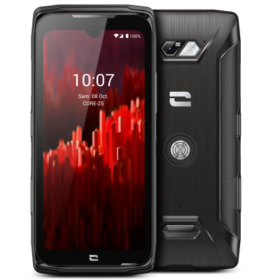

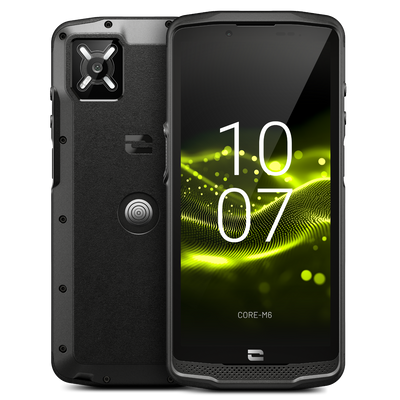
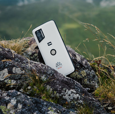
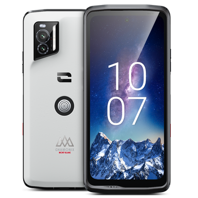
Outdoor mode: up to +25% more battery life
IP68, saltwater, dust
Resistance to repeated drops

Exclusive X-TREMESHIELD structure
Total waterproofing IP68 / IP69K
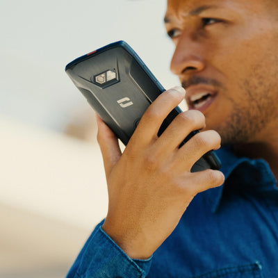
3 programmable buttons: SOS, AI & PTT
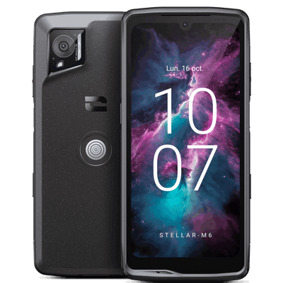
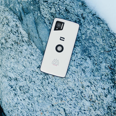
IP68, saltwater, dust
Outdoor mode: up to +25% more battery life
Resistance to repeated drops
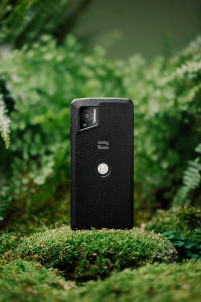
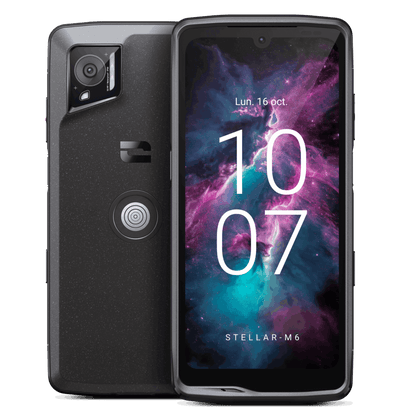
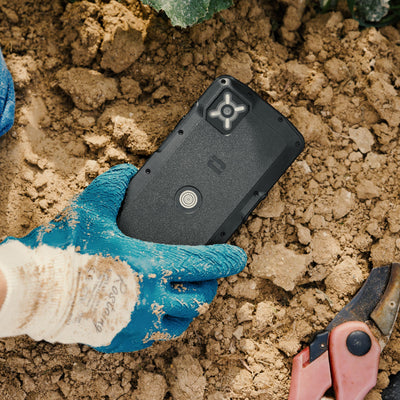
3 customizable action buttons, 1 SOS button
5G, Wifi6/6E, X-LINK, X-SPACE
Biometric security for sensitive data


ET SI TROUVER VOTRE SMARTPHONE ETAIT AUSSI SIMPLE QU'UNE CONVERSATION


When it comes to sustainability, it’s not words but actions that make the difference. So we took action.
Phones resistant to all challenges
A 5-year warranty, unique on the market
Designed to last, made to be repaired


Crosscall and Telefónica team up for "5G Emergencies"
"5G Emergencias," a pioneering program to validate the evolution towards high-speed in emergency communications in Spain Crosscall and Telefónica were selected to deploy the "5G Emergencias" program, a large-scale European initiative aimed at testing and validating the contribution of 5G technology in emergency communications. Funded by the NextGenerationEU fund as part of the Recovery, Transformation, and Resilience Plan, the project aims to subject networks and terminals to real operational situations to draw concrete lessons for the evolution of critical communication systems. In Spain, the program is led by the Generalitat Valenciana, specifically by the Valencian Agency for Security and Emergency Response (AVSRE), which entrusts project coordination to Infraestructures i Serveis de Telecomunicacions i Certificació, S.A.U (ISTEC). These two public entities are involved in crisis management, rescue coordination, and the integration of technologies for civil protection. A project rooted in a territory and its operational realities The program aims to evaluate the reliability and effectiveness of 5G technology through four test phases, each representative of real intervention conditions, diverse environments, and operational constraints. Dense urban environment – Valencia, La Cridà : management of a large urban event with risk of network saturation and multiple simultaneous communication flows. Industrial zone – Almussafes : simulation of an accident involving chemical risk, in an environment with irregular network coverage and significant physical constraints for equipment. Isolated natural environment – Benagéber Dam : simulation of a forest fire and an air accident, combining 5G/satellite connectivity, aerial and underwater drones, in areas where connectivity is not guaranteed. Urban environment – Valencia, Emergency Coordination Center : simulation of solution deployment in a context directly related to operations, coordination, and intervention supervision. The goal is to leave nothing to chance and to ensure that the program's conclusions accurately reflect operational reality in all its diversity. "Our mission is to provide institutions with the best critical communication tools. This pioneering project clearly demonstrates that improving interoperability and data quality optimizes real-time decision-making." Juan De Mingo, Head of Sales – Crosscall CORE-Z5: a terminal designed for emergency communications In each of these four environments, Crosscall's CORE-Z5 was selected as one of the evaluated devices. Already deployed with numerous public organizations in Europe and awarded the title of "Best MCX Product of the Year" at Critical Communication World 2024, it was designed to meet the most critical operational requirements: Durability and waterproofing: IP68/IP69K and MIL-STD-810H certifications — resistant to prolonged immersion, shocks, vibrations, extreme temperatures, and dust. PTT Ready: integrated Push-to-Talk button, ensuring immediate availability and optimized ergonomics for instant communication between responders. Network performance: CORE-Z5 is designed to operate on 5G networks and private networks, leveraging the capabilities of "network slicing," ensuring a dedicated and prioritized network slice for emergency traffic, even in congested or high-demand environments. The CORE-Z5 is deployed alongside an ecosystem of accessories specifically designed for the field: the X-COMM, a Bluetooth micro-speaker for reliable hands-free communication; the X-POWER, a magnetic external battery that doubles the device's autonomy; and the X-POWERSTATION, a multi-device charging platform that ensures continuous availability between service shifts. Thanks to this terminal, Crosscall and Telefónica offer a comprehensive solution, combining network performance and equipment reliability in the field. Expected results for all of Europe The "5G Emergencias" program aims to generate concrete and applicable results at the European level. The conclusions from the various scenarios will be submitted to the European Commission in June 2026. The goal is to identify deployment models that can be replicated in other territories, taking into account local specificities while relying on a common technological foundation. This project highlights Crosscall's strong expertise in emergency communication, as well as its ability to support the evolution of uses and infrastructures on the ground at a European scale.

What is the best battery life for a rugged smartphone?
What is the best battery life for a rugged smartphone? You've probably experienced the battery dying during an outing and had to turn off GPS or the screen to save what remains. Situations like this can quickly ruin a workday or an outdoor trip. With a phone truly designed for your activity, this shouldn't be a problem. In general, the battery life displayed by regular smartphones is hard to interpret without really knowing the testing protocols. As a result, the displayed battery life rarely corresponds to real usage... That's the whole difference between advertised battery life and real battery life. The mAh figure indicated on the product sheet remains a technical specification that doesn't say much about the battery's behavior in real-world use. A new European energy label now requires brands to communicate battery life measured under real conditions, not just standby. This battery life corresponds to the duration of smartphone use with a full charge, expressed in hours and minutes per battery cycle. It is obtained through a European protocol common to all manufacturers: the phone undergoes 2.5-hour test cycles simulating various daily uses (4G calls, web browsing, video playback, and standby phases) until it completely shuts down. The result thus indicates how long the smartphone can operate on a single charge according to a standardized usage scenario, offering a more reliable comparison between models. For a professional, on a construction site, on tour, in the field, or for someone practicing outdoor activities, battery life is not a minor detail. This is what allows you to get through an entire day without relying on a power outlet or an additional charge during the day. A smartphone designed to last must be able to keep up, even when the day gets longer. What is good battery life for a rugged smartphone? Today, most smartphones have around 6,000 mAh capacity, and some exceed 7,000 mAh. But for a rugged smartphone, this number is not the most important. What matters is the real battery life: that is corresponds to the usage conditions defined by the product's energy label. On this point, aiming for at least 48 hours of real battery life is a good benchmark for regular field use. The STELLAR-X5s Chamonix-Mont-Blanc Edition, for example, lasts up to 54 hours in real conditions, a sufficient margin to cover an extended day or outing. Needs then vary depending on usage: for basic office use (calls, emails, light browsing), the battery easily lasts; as soon as GPS, photos, and business apps are added, consumption increases significantly; in intensive outdoor use (tracking, maps, location sharing), a standard battery can drain in a few hours. Why do two phones with the same battery capacity not have the same battery life? Three main factors explain the difference: the processor (some consume less at equal performance), the screen (a 120 Hz panel consumes more than a 60 Hz panel), and software optimization, which determines how the system manages background apps. At equal capacity, a smartphone with long battery life A well-optimized device will therefore last significantly longer than a standard model. Which uses consume the most battery? GPS, photo, video, and business applications : GPS is one of the most power-hungry functions. It’s not the signal reception that drains power, but the continuous position calculation, map updates, and constant communication with satellites. Yet it’s hard to do without: it’s often a safety reference, whether for a delivery person, a security guard on patrol, or a hiker. The camera and video also consume a lot, especially outdoors: difficult lighting conditions put more strain on the processor and screen, and advanced video modes require heavier image processing. Added to this are business applications: reports, barcode scanning, geotagged photos, walkie-talkie apps, which often run in the background all day. Mobile network, 5G, and tethering A smartphone in a low coverage area is never truly at rest: it regularly sends signals to try to connect to a tower. This repeated cycle consumes a lot of power, especially in isolated areas, basements, or poorly covered industrial zones. 5G, being faster, also drains the battery more than 4G when kept continuously active, as does tethering, which is often used in the field to connect a tablet or laptop. Why does battery life decrease outdoors? The impact of cold and weather conditions Temperature has a direct impact on the battery. A battery works optimally between 15 and 35°C. Below -5°C, the battery seems to drain much faster. The phone may even shut down while still showing 20% charge. This phenomenon is reversible once back to room temperature, but on a construction site in winter or in the mountains, this is not always possible. Conversely, staying above 40-45°C for long periods permanently degrades the battery. That is why a rugged phone must be able to operate over a much wider temperature range than a standard smartphone, ideally from -20°C to +60°C. Field and mobility constraints In an office environment, a smartphone usually stays near a power outlet and is not heavily used. Outdoors, the situation is different: full days away from any recharge, constant movement, GPS, network, and screen on simultaneously, sometimes rain or dust as well. This combination of constraints explains why a smartphone discharges much faster in the field than in the office, even with the same battery capacity. What battery life to expect based on your activity? Battery life needs vary depending on the profession or activity. Some concrete benchmarks: Building site : the construction professionals often work outdoors, with site tracking apps and geotagged photos, without always having access to a power outlet. It is advised to aim for one and a half to two days of battery life. Logistics : the field teams perform parcel scanning, GPS, and communication throughout the day. Battery life must cover a full day without recharging margin. Security : the security agents often work irregular hours or night shifts, with walkie-talkie and geolocation active continuously. A battery life of 24 to 48 hours in communication is recommended. Hiking and outdoor : for outdoor activities, between GPS, tracking, and no recharging for several days, aiming for 48 hours or more is essential for safety. Activity Main uses Recommended real battery life Construction / building site Photos, business apps, outdoor 36 to 48h Logistics / transport GPS, scanning, continuous communication 24 to 36h Security Walkie-talkie, geolocation, irregular hours 24 to 48h Hiking / outdoor Intensive GPS, tracking, no recharging 48h and more How to choose a rugged smartphone with long battery life? Some criteria to consider: Battery capacity (mAh) : the higher it is, the greater the potential battery life, although it alone is not enough to judge the real endurance of a device. Software optimization : a good professional smartphone combine a large-capacity battery with low-power components and efficient background app management. Power-saving modes : beyond the classic power-saving mode, which restricts all functions, some smartphones allow more precise settings. Crosscall’s Outdoor Mode, for example, can increase battery life by up to 25% without sacrificing essential functions. Real battery life rather than just battery capacity number : this is the most reliable criterion. A model that lasts 48 hours or more in real use is preferable to a high mAh number that is not representative of field conditions. On these criteria, models like the STELLAR-X5s or its version STELLAR-X5s Chamonix Mont-Blanc combine high-capacity battery, Outdoor Mode, and IP68 waterproofing to last up to 54h in real conditions. For more versatile professional use, the CORE-M6 offers a real battery life of 80h, IP68/IP69K waterproofing, and programmable buttons suited to the field. What level of battery life is expected for a rugged smartphone? For sustained professional or outdoor use, you should aim for at least 24 to 48 hours of real battery life, with GPS active and network in use. The most durable models, like the STELLAR-X5s Chamonix-Mont-Blanc, reach up to 54 hours in real conditions. Does cold reduce battery life? Yes, significantly. Below -5°C, chemical reactions in the battery slow down, which accelerates discharge and can cause the phone to shut down abruptly even though there is still charge displayed. That’s why rugged smartphones are designed to operate over a much wider temperature range than a standard model. Does GPS consume a lot of battery? Yes, it is one of the most power-hungry functions. Continuous position calculation, map updates, and constant communication with satellites heavily impact battery life, especially when the network is weak at the same time. What battery life is expected for a construction site smartphone? On a construction site, between business applications, geolocated photos, and extended outdoor use, it is recommended to aim for 36 to 48 hours of real battery life to cover a full workday with a safety margin, without relying on easy access to a power outlet.

Thanks to a strategic partnership with Quality One and AT&T, the French manufacturer is deploying its first FirstNet Trusted™ certified Push-to-Talk terminal in the United States, intended for emergency services, law enforcement, and critical mission operators. Crosscall today announces its entry into the American critical communications market. This new stage of its international development is based on a strategic partnership with Quality One, an American specialist in mobile terminal deployment and certification, as well as with AT&T. On this occasion, Crosscall is launching in the United States the CORE-P6, a next-generation Push-to-Talk terminal certified FirstNet Trusted™, designed to meet the needs of first responders, public safety services, and professionals operating in demanding environments. After supporting more than 350,000 MCX solution users in Europe, including security forces, emergency services, and critical infrastructure operators, Crosscall is taking a new step in its development by bringing its critical communications expertise to the American market. This field experience with organizations that have high demands now provides a solid foundation to support the transformation of critical communications in the United States. This arrival in the United States is part of Crosscall’s development strategy in the critical communications market, a sector undergoing major transformation due to the gradual migration from traditional radio networks to high-speed solutions integrating voice, data, and business applications. The company intends to leverage the experience gained from hundreds of thousands of professional users in Europe to support this evolution in the American market, considered one of the most dynamic and advanced in the world in this field. “Crosscall’s entry into the American market marks a major milestone in our international development. The needs of professionals engaged in critical missions are universal: they require reliable, robust, and easy-to-use equipment in all situations. Thanks to our partnership with Quality One and AT&T, our ambition is to help organizations go beyond the limits of traditional radio by combining rugged, field-adapted terminals, high-speed capabilities, and the essential ease of use for critical operations. The United States represents a strategic step in this ambition, given its leading role in the evolution of critical communications worldwide.” Nicolas Zibell, CEO of Crosscall. A strategic partnership with Quality One and AT&T to access the FirstNet ecosystem To support its entry into the U.S. market, Crosscall relies on Quality One, a key partner in mobile device deployment in the United States. With over 500 launches completed with the country’s main telecom operators, Quality One played a crucial role in integrating the CORE-P6 into the FirstNet ecosystem and its listing within AT&T’s distribution channels. This partnership allows Crosscall to access one of the most demanding and advanced critical communications ecosystems in the world today. Available from June 26, the CORE-P6 will be sold in the United States through AT&T’s professional and consumer distribution networks and accessible to FirstNet users, the national network dedicated to emergency services, public safety forces, and professionals engaged in critical missions. This launch marks the culmination of several years of Crosscall’s investment in critical communications and represents a new step in its ambition to become a key player in the transition to MCX solutions on an international scale. CORE-P6: the 5G PoC device designed for critical communications - Designed to support organizations' transition to Push-to-Talk over Cellular (PoC), the CORE-P6 brings the ergonomics and ease of use of professional radios into a high-speed 4G/5G environment. Its T-shaped design, large Push-to-Talk (PTT) button, and rotary channel selector ensure immediate handling by users familiar with professional radios. - Simplified integration into professional environments PTT applications are built-in, and the device natively integrates with the X-LINK™ and Klick Fast ecosystems. Built on the AOSP architecture, it is compatible with major MDM solutions on the market such as SOTI and VMware Workspace ONE. It is also compatible with AT&T Enhanced Push-to-Talk and FirstNet Rapid Response services, and will be compatible with FirstNet Fusion upon its launch, facilitating its integration into existing critical communication infrastructures. - Audio quality designed for the loudest environments In the field, audio quality is at the heart of the user experience. The CORE-P6 features a high-power forward-facing speaker combined with three microphones. Thanks to X-SOUND 360° technology and noise reduction optimized by artificial intelligence, the device can achieve up to -60 dB ambient noise attenuation, ensuring maximum intelligibility even in the loudest industrial environments. - Durability designed for the most demanding operational environments Certified MIL-STD-810H and IP68, the CORE-P6 combines durability, autonomy, and service continuity. Its removable battery offers up to 58 hours of Push-to-Talk use and remains operational in extreme conditions ranging from -20°C to +60°C. Its 4G/5G and Wi-Fi 6/6E connectivity, dedicated SOS button, and fall detection function make it perfectly suited for critical missions. - Sustainable technology designed for the long term Compatible with 4G/5G, the CORE-P6 aligns with Crosscall’s historic commitment to sustainability. It comes with a three-year warranty, operating system updates, and four years of security updates, offering organizations a reliable and long-lasting solution for their critical operations. - A complete ecosystem of professional accessories The CORE-P6 comes with an ecosystem of accessories specially designed for operational use: in-vehicle solutions, single or multi-device charging stations, communication accessories, and remote control devices. A set designed to provide greater flexibility and efficiency for teams in the field. About Quality One: Quality One is a key player in the United States in mobile device lifecycle management services. The company supports manufacturers, telecom operators, distributors, and users throughout North America. Founded in 1993 and based in Orlando, Florida, Quality One offers an integrated service covering the entire value chain: device development and certification, engineering, logistics management, storage and distribution services (3PL), after-sales support, quality assurance, and e-commerce management. With over 500 successful product launches, recognized expertise with major American telecom operators including AT&T, and more than 200 employees, Quality One is a leading partner for deploying mobile devices in the American market. The company has been recognized as one of the "Top Workplaces" in the United States for six consecutive years. About AT&T AT&T is one of the world's leading telecommunications operators. The group provides mobile, internet, and connectivity services to over 100 million individuals and nearly 2.5 million businesses in the United States. With more than 150 years of innovation, AT&T is now developing next-generation communication solutions, particularly around 5G and critical networks.
You want to
equip your teams.
Discover customized solutions
tailored to each industry
for your business.

Free shipping
Free shipping on orders of €149 or more

Pay at your own pace up to 60x*
Pay at your own pace with Floa: 3, 4, 10, or up to 60x*

RATED 4.6/5 BY CUSTOMERS
Based on over 10,000 customer reviews
Get 10% off right now!
Sign up to unlock your discount and get early access to our exclusive offers and new releases.